Aids to Navigation
You can download the Canadian Aids to Navigation Map (PDF) and Reference Guide (PDF) from the Canadian Coast Guard website.
Major / Fixed Aids to Navigation
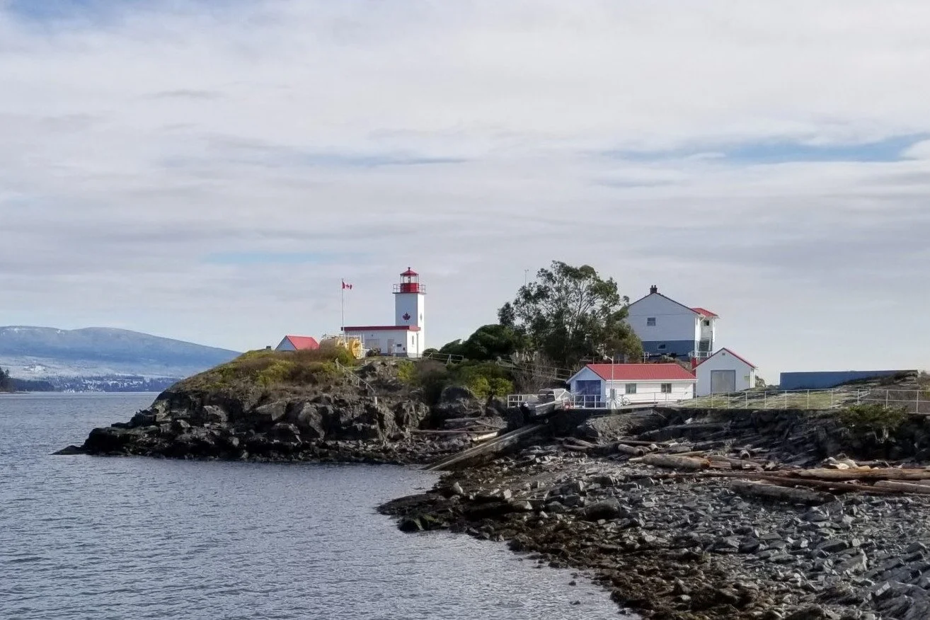
Major fixed aids—such as prominent lighthouses and beacons—are permanent, shore-based navigation marks that often feature a primary light and an emergency light (and may include a fog signal or RACON). They’re identified by their structure (colour/shape) and, where lighted, by their light characteristics (colour and flash pattern) as published in the List of Lights, Buoys and Fog Signals. Read more…
Lateral Buoys and Isolated Danger Aids
Canada uses the IALA Maritime Buoyage System, adopted by most major maritime nations. This system includes lateral, isolated danger, cardinal, and special marks used to support safe navigation. Read more…
Cardinal Aids
Cardinal marks indicate the safest/deepest water by referencing the cardinal points: North, East, South, and West. Read more…
Special Buoys
Special buoys provide specific information to mariners (for example, to mark areas or features). They are not primarily navigation aids, and their shapes can vary. Read more…
Light Flashing Characteristics
Light colours support quick recognition within the Canadian Aids to Navigation system: red/green for lateral marks, white for cardinal/isolated danger/safe water marks, and yellow for special marks. For full details, refer to the Canadian Coast Guard website resources.
Looking for vessel navigation lights instead? Go here.
Attribution: Contains information published by the Canadian Coast Guard and Fisheries and Oceans Canada, licensed under the Canadian Coast Guard Open Information Licence. Official documents are available for free download from the Canadian Coast Guard website and the Notices to Mariners (NOTMAR) publications.
Major Lighted Aids
Major lighted aids to navigation may display a main light, are equipped with an emergency light, and may be equipped with a fog signal or RACON.
Light
The colour and character of the light are advertised on the chart and on the publication “list of lights, buoys and fog signals”. The colour of the structure may not have lateral significance. The elevation of the light above the water level (metres (m) or feet (ft)) and nominal range (nautical miles (M)) may be indicated. Equipped with an emergency light of reduced intensity, Fl(6)15s. When the colour of the light is not specified for any marine aid to navigation light, it is white.
Fog Signal
Signal characteristics are advertised on the chart and on the “list of lights, buoys and fog signals”.
RACONS
A RACON (radar beacon) transmits a Morse code pulse that can be seen on a radar display distinguishing it from surrounding radar targets. Information concerning RACONS can be found in “radio aids to marine navigation”.
Lateral Buoys and Isolated Danger Aids
Here’s a refreshed, cleaner version with consistent structure and easier scanning (same technical content, less repetition). You can paste this into Squarespace.
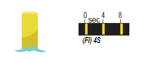
Port Hand Buoy
Description
Colour: Green
Light (if equipped): Green Fl 4s or Q 1s
Shape (unlighted): Flat top
Topmark (if equipped): Single green cylinder
Markings: Letter + odd number(s)
Retroreflective: Green
User’s Guide
Marks the port (left) side of a channel, or a danger that must be kept to port when proceeding upstream.
Port Hand Buoy
Port Bifurcation Buoy
Description
Colour: Green with one red horizontal band
Light (if equipped): Green Fl(2+1) 6s or Fl(2+1) 10s
Shape (unlighted): Flat top
Topmark (if equipped): Single green cylinder
Markings: Lettered (no numbers)
Retroreflective: Green
User’s Guide
Marks where a channel divides when proceeding upstream. Keep this buoy to port when taking the preferred (main) channel.
Port Bifurcation Buoy
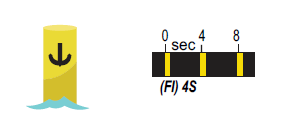
Starboard Hand Buoy
Description
Colour: Red
Light (if equipped): Red Fl 4s or Q 1s
Shape (unlighted): Pointed (conical) top
Topmark (if equipped): Single red cone (point up)
Markings: Letter + even number(s)
Retroreflective: Red
User’s Guide
Marks the starboard (right) side of a channel, or a danger that must be kept to starboard when proceeding upstream.
Starboard Hand Buoy
Starboard Bifurcation Buoy
Description
Colour: Red with one green horizontal band
Light (if equipped): Red Fl(2+1) 6s or Fl(2+1) 10s
Shape (unlighted): Pointed (conical) top
Topmark (if equipped): Single red cone (point up)
Markings: Lettered (no numbers)
Retroreflective: Red
User’s Guide
Marks where a channel divides when proceeding upstream. Keep this buoy to starboard when taking the preferred (main) channel.
Starboard Bifurcation Buoy
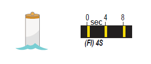
Fairway Buoy (Safe Water)
Description
Colour: Red and white vertical stripes
Light (if equipped): White Mo(A) 6s or LFl 10s
Shape (unlighted): Spherical top
Topmark (if equipped): Red sphere
Markings: Lettered (no numbers)
Retroreflective: White
User’s Guide
Indicates safe water—often used for landfalls, channel entrances, or channel centres. May be passed on either side; keep to port when proceeding in either direction.
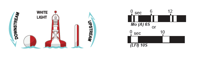
Fairway Buoy
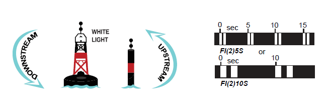
Isolated Danger Aid
Description
Colour: Black with one red horizontal band
Light (if equipped): White Fl(2) 5s or Fl(2) 10s
Topmarks: Two black spheres
Markings: Lettered (no numbers)
Retroreflective: White
User’s Guide
Marks an isolated danger with navigable water all around (e.g., shoals, rocks, wrecks). Always consult your chart for details (position, depth, extent of hazard).
Attribution: Contains information published by the Canadian Coast Guard and Fisheries and Oceans Canada, licensed under the Canadian Coast Guard Open Information Licence. Official source materials are available on the Canadian Coast Guard website and in the Notices to Mariners (NOTMAR) publications.
Isolated Danger Aid
Cardinal Aids
Cardinal aids may be buoys or fixed aids. They indicate where the safest or deepest water lies by referencing the cardinal points of the compass. There are four types: North, East, South, and West.
Below are descriptions of each cardinal aid.
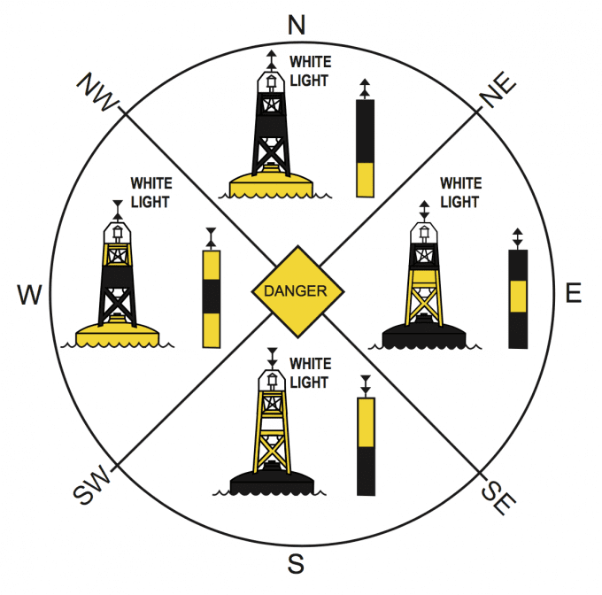
North Cardinal Aid
Description
Colour: Black over yellow (top half black, bottom half yellow)
Topmark: Two black cones, one above the other, both pointing up
User’s Guide
Safest water is to the north of the mark.
North Cardinal Aid
East Cardinal Aid
Description
Colour: Black with a single horizontal yellow band
Topmark: Two black cones, one above the other, base to base
User’s Guide
Safest water is to the east of the mark.
East Cardinal Aid
South Cardinal Aid
Description
Colour: Yellow over black (top half yellow, bottom half black)
Topmark: Two black cones, one above the other, both pointing down
User’s Guide
Safest water is to the south of the mark.
South Cardinal Aid
West Cardinal Aid
Description
Colour: Yellow with a single horizontal black band
Topmark: Two black cones, one above the other, point to point
User’s Guide
Safest water is to the west of the mark.
Note on lights: If equipped, cardinal aids use distinctive flash patterns to support identification at night or in reduced visibility (refer to official Canadian Coast Guard references).
Attribution: Contains information published by the Canadian Coast Guard and Fisheries and Oceans Canada, licensed under the Canadian Coast Guard Open Information Licence. Official source materials are available on the Canadian Coast Guard website and in the Notices to Mariners (NOTMAR) publications.
West Cardinal Aid
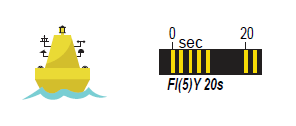
Special Buoys
Special buoys provide information, cautions, or restrictions—they are not primarily used to guide navigation.
General characteristics
Shape has no significance (varies by use).
Lights: Yellow (if equipped); flash pattern varies by buoy type.
Topmark: Cautionary, scientific, and anchorage buoys may display a yellow “X” (if equipped).
Markings: May be lettered (generally no numbers).
Retroreflective: Yellow.
Cautionary
Marks areas of caution or special activity such as firing ranges, underwater pipelines/cables, race courses, seaplane bases, or areas where no through channel exists.
Anchorage
Marks the perimeter of a designated anchorage area. Consult the chart for depth and anchoring considerations.
Mooring
Used for mooring or securing vessels. Be alert—another vessel may already be attached to the buoy.
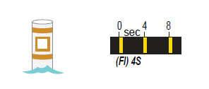
Information
Provides local information (e.g., locality, marina, campsite). Follow the guidance displayed within the orange square.
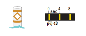
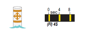
Hazard
Marks hazards such as shoals or rocks. Details about the hazard are shown within the orange diamond.
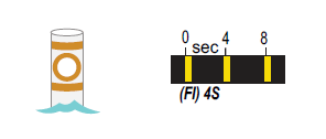
Control
Indicates restrictions such as speed limits or wash/no-wake zones. Follow the instruction shown within the orange circle.
Keep-out
Marks areas where boats are prohibited.
Scientific (ODAS)
Ocean Data Acquisition System (ODAS) buoys collect meteorological and other scientific data.
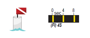
Diving
Marks an area where diving activity is in progress. These buoys may not be charted—proceed with caution and give divers space.
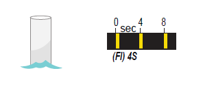
Swimming
Marks the perimeter of a swimming area. These buoys may not be charted—reduce speed and keep clear.
Attribution: Contains information published by the Canadian Coast Guard and Fisheries and Oceans Canada, licensed under the Canadian Coast Guard Open Information Licence. Official source materials are available from the Canadian Coast Guard website and in the Notices to Mariners (NOTMAR) publications.